Climate Change and Environment (CCE)
Sustainable and Resilient Solutions for Climate, Environment, and Disaster Management
Sustainable and Resilient Solutions for Climate, Environment, and Disaster Management
For many years, IWM has been actively engaged in research and applied studies on climate change and environmental issues, including climate projections, impact assessments, and modeling the impacts of climate change on floods, droughts, storm surges, salinity, and other hydro-climatic hazards. These efforts have been carried out in collaboration with national and international partners. Recognizing the growing importance of climate and environmental research, IWM envisioned establishing a dedicated unit to address these challenges in a focused and coordinated manner. The Climate Change and Environmental Unit aims to enhance resilience and sustainability by enabling better management of risks associated with climate change, environmental changes, and climate-induced disasters. Through the integration of science-based climate and environmental information into planning, policy, and practice at global, regional, and national levels, the unit strives to support adaptation, mitigation, and long-term sustainable development.

The Institute of Water Modelling (IWM), through its Climate Change and Environment (CCE) Unit, provides specialized climate services to support evidence-based planning, policy formulation, and climate-resilient development in Bangladesh. These services integrate scientific research, advanced modelling, and capacity development to address current and future climate challenges.
The Institute of Water Modelling (IWM) offers world-class expertise in Environmental and Social Impact Assessments (ESIA) across a diverse portfolio of infrastructure and development sectors. With a proven track record, we deliver scientifically robust and socially inclusive assessments tailored to meet both national regulatory mandates and international standards, including guidelines set by the World Bank, ADB, JICA, UNDP, and IFC.
Our multidisciplinary approach has successfully supported large-scale projects in:
We provide a full spectrum of environmental and social services, leveraging advanced technology to ensure precision:
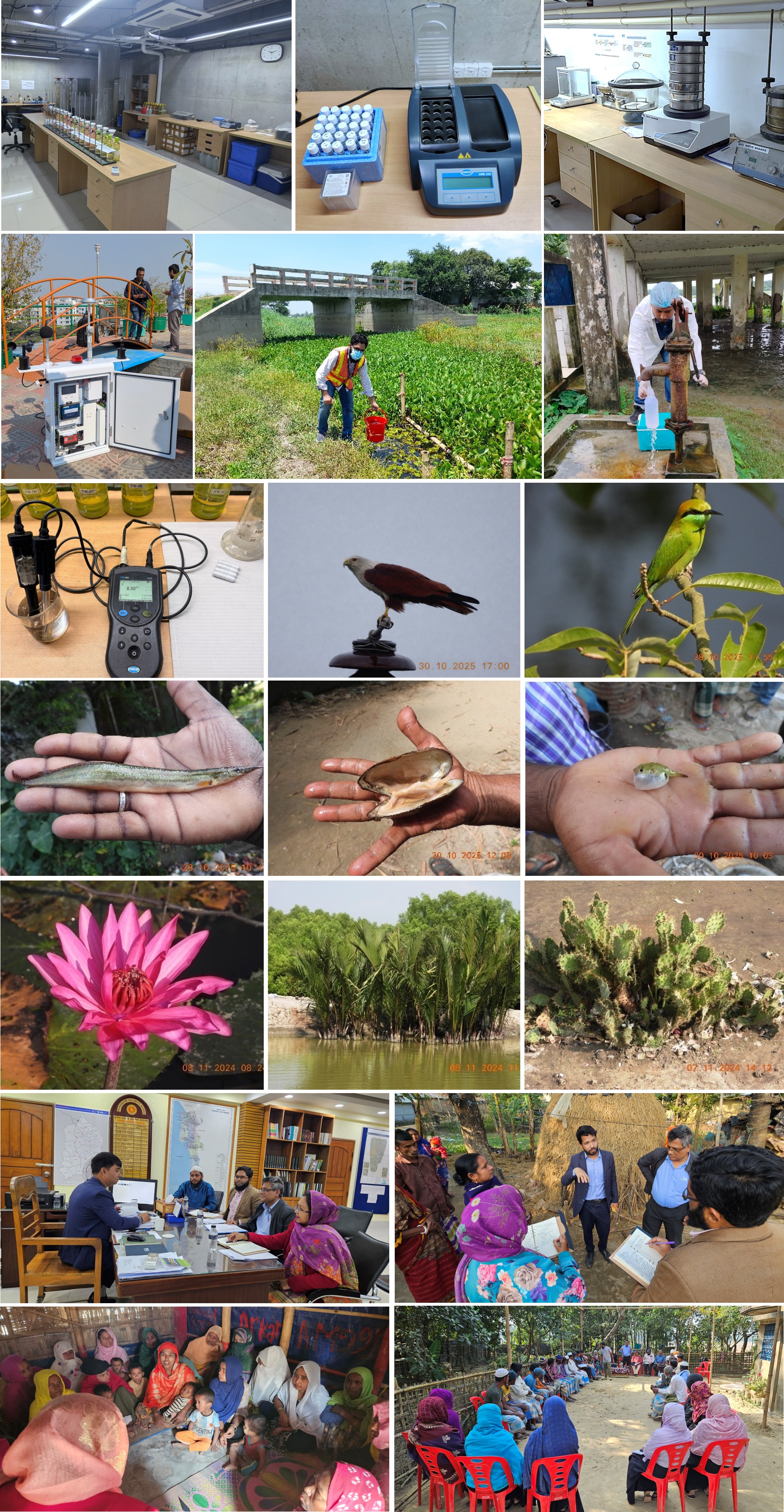
IWM maintains a fully equipped water and soil testing laboratory, ensuring that all assessments are backed by accurate, evidence-based data. Our field capabilities include:
Our strength lies in our people. IWM’s Climate Change and Environment (CCE) Unit is powered by a team of highly qualified specialists, including:
At IWM, we are dedicated to fostering sustainable development. By combining innovative analytical solutions with a deep understanding of complex environmental and social systems, we ensure that every project we touch is resilient, compliant, and socially responsible.

Our Milestone Projects
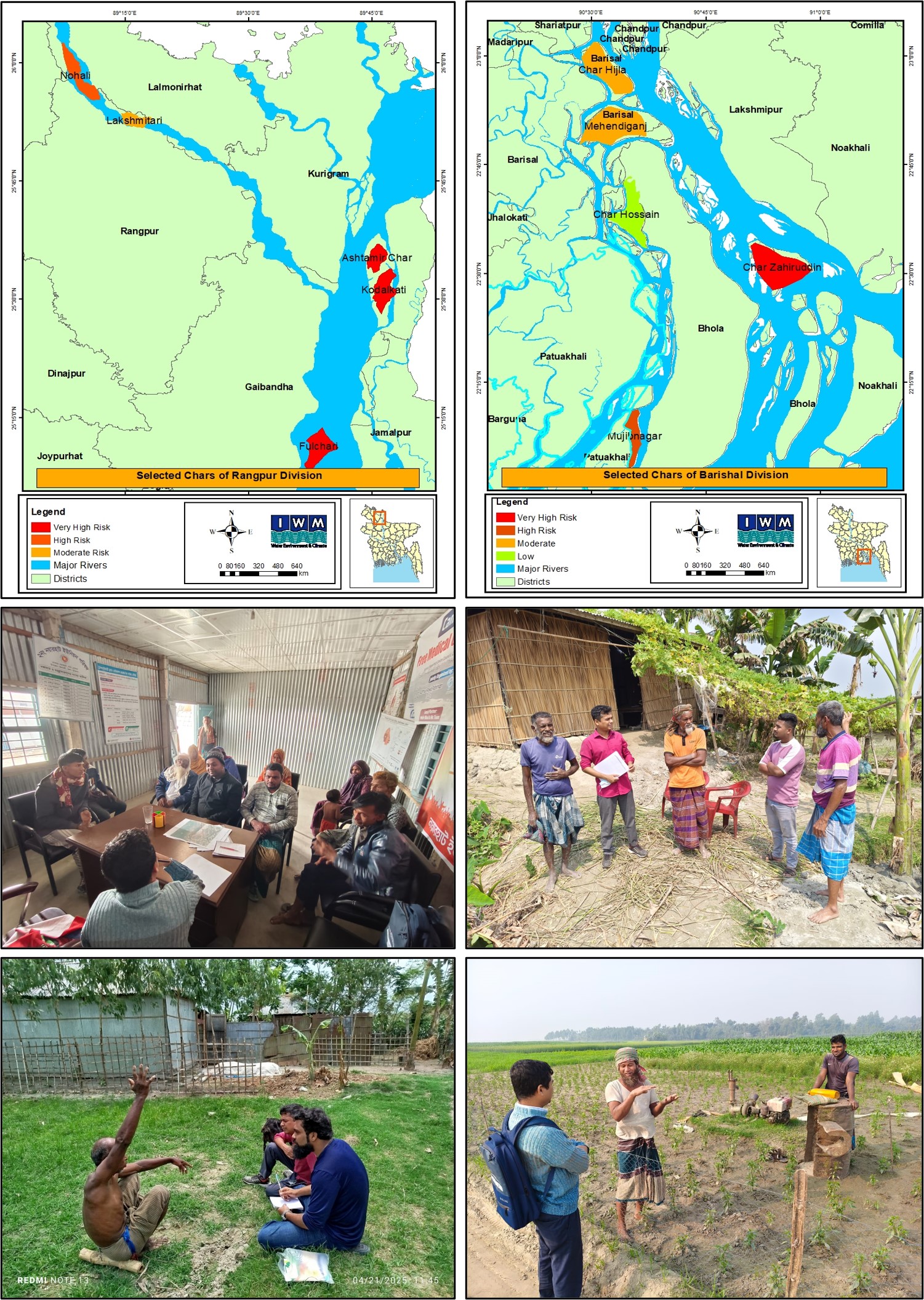
The project “Assessing Climate Vulnerability and Risks of Coastal Islands and Riverine Char Lands in Bangladesh and Conducting Environmental Monitoring”, funded by the Adaptation Fund through UNDP and implemented by the Department of Environment (DoE), aims to enhance the climate resilience of vulnerable communities living on coastal islands and riverine chars. Its objectives include assessing climate risks, identifying adaptation options, preparing an Environmental and Social Management Plan (ESMP), and conducting environmental monitoring.
The project selected 10 chars and islands from Barishal and Rangpur Divisions through literature review, Google Earth imagery, and multi-criteria analysis, considering stability, size, population, and hazard exposure. Using IPCC AR6 frameworks, climate vulnerability and risk were assessed based on hazard, exposure, sensitivity, and adaptive capacity. Data collection included field visits, FGDs, KIIs, and case studies, while 35 socio-economic and biophysical indicators were normalized for vulnerability and risk assessing and mapping. The findings reveal that Char Zahiruddin, Kodalkati, Fulchhari, and Austomir Char are exposed to very high climate risks; Mujibnagar and Nohali fall under the high-risk category; Lakkhitari, Mehendiganj, and Char Hizla are classified as medium risk; while Char Hossain falls into the low-risk category.
The results reveal widespread erosion, frequent flooding, cyclones, and rising salinity, alongside limited access to education, healthcare, and infrastructure. Communities rely heavily on agriculture and fishing, with local adaptation practices such as raising house plinths, food storage, and protective barriers. To build resilience, the project highlights the need for embankments, cyclone shelters, cyclone resilient housing, improved connectivity, climate-smart farming, livelihood diversification, and ecosystem-based approaches. Strengthened policies, institutional support, and climate financing, including from Bangladesh Climate Change Trust Fund (BCCTF), Adaptation Fund (AF) and Green Climate Fund (GCF), are essential to ensure long-term resilience of Bangladesh’s chars and islands.
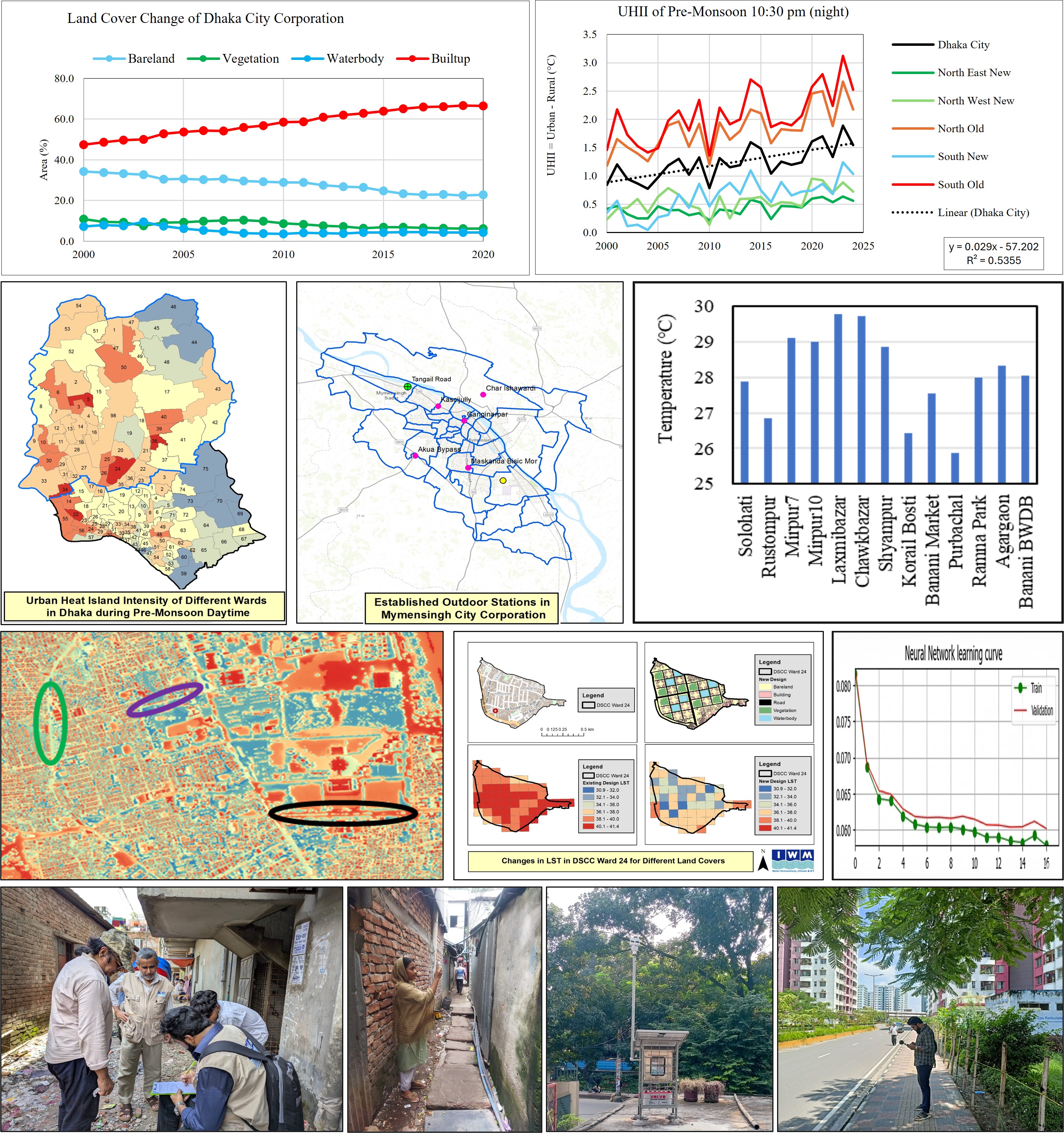
Bangladesh has undergone rapid urbanization over the last century, leading to significant Urban Heat Island (UHI) effects, where urban areas become hotter than surrounding rural regions, posing serious environmental and health challenges. Recognizing these risks, the Department of Environment (DoE) commissioned the Institute of Water Modelling (IWM) in November 2023 to implement the project “Assessment of Urban Heat Island Effect at City Level in Different Climate Change Scenarios.” The study focuses on Dhaka and Mymensingh, aiming to assess existing UHI conditions, identify contributing factors, project future impacts under different climate scenarios, and recommend policy-based mitigation strategies.
Urban areas replace natural vegetation with heat-absorbing structures like roads and buildings, reducing cooling through shade and evapotranspiration. Combined with dense construction, restricted airflow, waste heat emissions, and air pollution, these factors intensify UHI. To measure this, the study uses Urban Heat Island Intensity (UHII), derived from Land Surface Temperature (LST) differences between urban and rural areas. Regression analysis quantified the influence of land covers, while future land cover and temperature were forecasted using the CA-ANN method and a rule-based land cover transition approach.
IWM installed 24 manual, 9 automated, and 4 compact weather stations across Dhaka and Mymensingh. Findings indicate that densely built areas retain more heat at night. Thermal comfort modeling with SOLWEIG showed that road orientation, width, and shading strongly affect Mean Radiant Temperature (MRT). For instance, shaded north–south roads recorded MRTs near 50°C, while wide east–west roads without shade exceeded 79°C.
The combined effects of UHI and climate change amplify risks by prolonging heat exposure, worsening air quality, and increasing heatwave duration in the post-monsoon season. This intensifies health impacts such as heat stress, dehydration, skin irritation, headaches, fatigue, and respiratory illness, particularly for vulnerable groups. The project highlights strategies including expanding green infrastructure, reflective construction materials, shading requirements, and cooling stations to reduce UHI intensity, strengthen thermal comfort, and build climate-resilient cities.
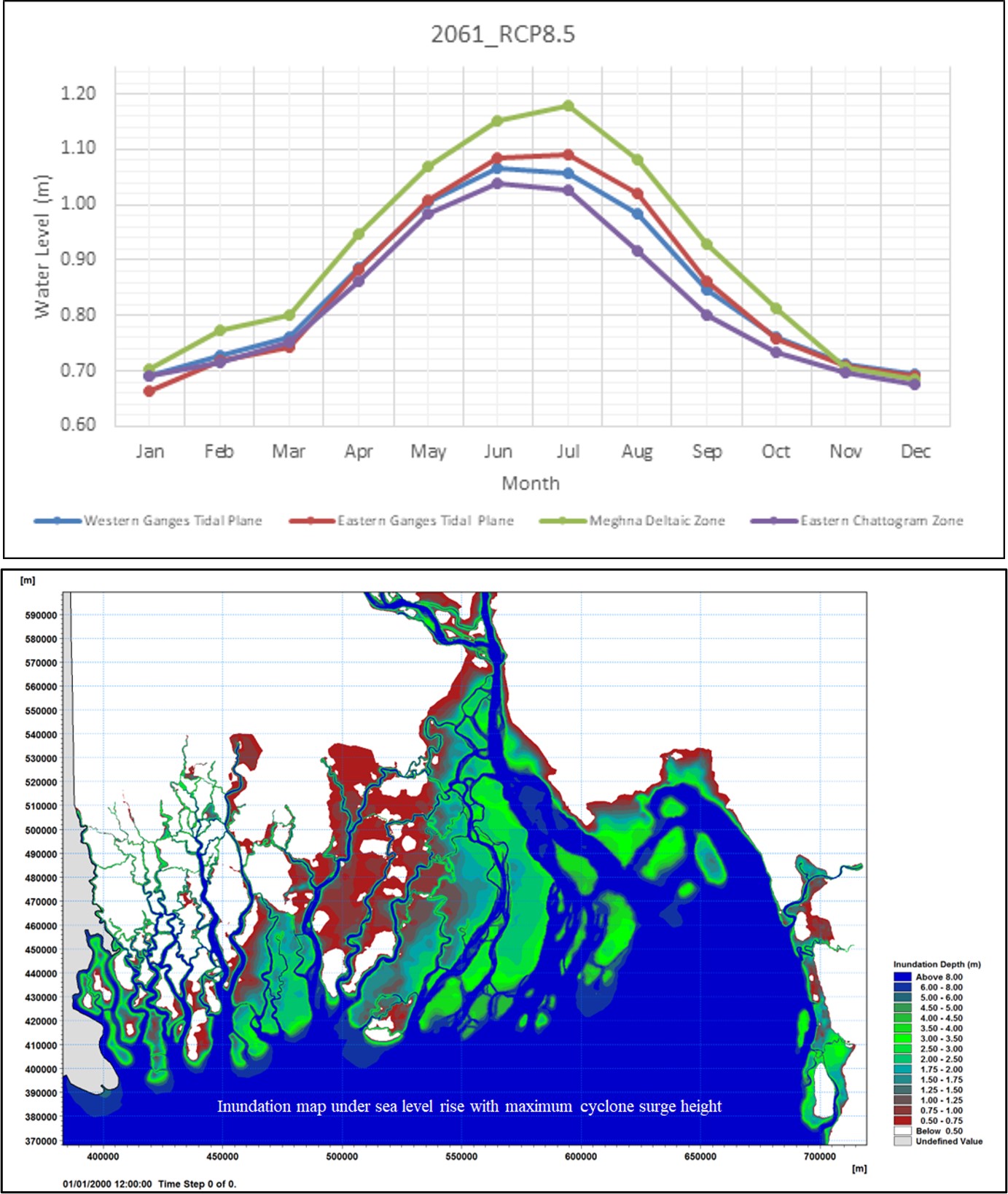
Bangladesh, with its low-lying coastal zones, is highly vulnerable to sea level rise and related climate impacts. To address these challenges, this project investigates spatial and temporal variations of sea level along the country’s three coastal regions, West, Central, and East. Seasonal patterns and zonal differences are analyzed to better understand how sea level fluctuations affect different parts of the coast.
Future sea level rise is simulated for mid-century (2035–2065) and end-century (2070–2100) under RCP 4.5 and RCP 8.5 scenarios, incorporating both global drivers and local influences such as land subsidence, tidal modulation, and ENSO variability. Hydrodynamic, wave, storm surge, and morphological modeling approaches are applied to capture the complex dynamics of the Bay of Bengal.
The study also evaluates the implications for coastal infrastructure, particularly polders. Overtopping risks and inundation extents are assessed for selected polders under rising sea levels and intensified storm surges. To support this analysis, the GBM basin model, river models, and Bay of Bengal model are updated and calibrated.
A key component of the project is stakeholder engagement. Detailed methodologies are developed through consultations with experts and decision-makers, ensuring that findings are relevant to adaptation planning. The project also emphasizes effective communication of results through reports, databases, and a dedicated web application, providing accessible information for policymakers.
By integrating advanced modeling with local considerations, the project delivers critical insights into future coastal risks, supporting climate-resilient planning and adaptive strategies for Bangladesh’s coastal communities.
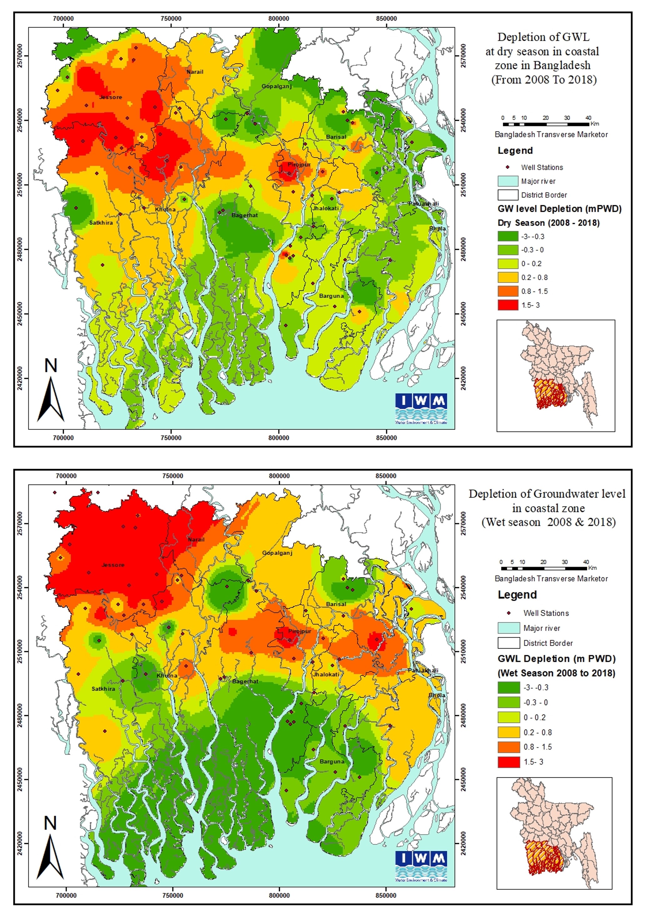
Groundwater is a critical resource for the coastal regions of Bangladesh, where surface water is often affected by salinity intrusion and climate change impacts. This project focuses on assessing groundwater resources and evaluating their vulnerability under changing climatic conditions, with a particular emphasis on aquifer characterization and salinity dynamics.
The study begins with a comprehensive review of existing reports and research on aquifer characteristics, salinity modeling, and groundwater investigations in coastal areas. Lithological data from secondary sources are collected and analyzed to prepare hydro-stratigraphic cross-sections, enabling a clear understanding of aquifer extents and properties. Aquifer characteristics such as storage coefficients (Sy, Ss) and hydraulic conductivity (Kh) are defined and mapped, providing critical insights into groundwater availability and dynamics.
Groundwater level (GWL) data from representative stations are compiled to generate long-term hydrographs, offering an understanding of historical groundwater trends. Spatial distribution maps of GWL are also prepared to highlight regional variations. In parallel, surface water (SW) and groundwater (GW) salinity data are collected and analyzed to assess both temporal and spatial trends in salinity intrusion. Salinity contour maps are developed to identify vulnerable zones and track changes over time.
A key task of the project is updating the existing groundwater salinity model previously developed under the JAR project for Khulna, Satkhira, and Jessore. By integrating updated datasets and climate considerations, the model enhances the capacity to simulate future salinity scenarios and groundwater stress in coastal aquifers.
The findings provide valuable guidance for groundwater management, salinity mitigation, and climate adaptation planning in Bangladesh’s vulnerable coastal belt.
Our Core Team

Email: ahk@iwmbd.org
Mobile: 01915-494677, 01841-930092

Email: iap@iwmbd.org
Mobile: 01841930026

Email: mtz@iwmbd.org
Mobile: 01680514668

Email: sbr@iwmbd.org
Mobile: 01312869281

Email: ifm@iwmbd.org
Mobile: 01701023576

Email: adi@iwmbd.org
Mobile:

Email: tsh@iwmbd.org
Mobile:

Email: oaf@iwmbd.org
Mobile: 01303779327